After Beechmont turned on a beautiful day yesterday, it was Springbrook's turn this evening. My legs felt like lead climbing the mountain in the fading light -- evidently darkness takes a while to actually arrive at this time of year. Nevertheless, it didn't stop the beauty of this place from making itself apparent. First of all was the mist closing in above 920 metres -- always a special delight at night. It was for moments like this that I spent $600 on a lighting system, although that can complicate things with the white, ghostly glow that appears when lighting these conditions.
Right at the top of the mountain, a colony of fire-flies had decided to nest in a tree. The flashes of the light were quite spectacular to behold for a few moments, while I pondered the descent into the mist and the aforementioned white glow. It was soon after this that I got to watch the moon rise -- twice! The first time was on Lyrebird Ridge on the western end of the escarpment. A few minutes and a 350-metre descent later, I was able to behold a repeat performance, this time from the eastern side of the escarpment. Further down the mountain, I got another view of the glow worms that make this place what it is -- even if they're less prevalent under a full moon.
Nights like this are what living is all about.
Friday, April 22, 2016
Anything you can do...

Thursday, April 21, 2016
BLACK GOLD
The dogs thought it was their lucky day - two huge sacks of dog food at the side of a quiet country road. We popped the bags into the boot of the car and brought them home.
 As soon as Pip and Toby got another whiff they got really excited - horse poo - their favourite!
Finally we have managed to get some horse manure for the garden - normally when we pass anywhere offering it for free, there is none left. Our luck was in today. It is safely tucked away out of the dogs reach, waiting for time to work its magic and turn this muck into black gold for the garden.
As for the dogs - well they'll just have to make do with their usual.
The Aged Aunt is fine - but refuses to wash or change just in case she knocks her head... We'll try again tomorrow.
Your Pa has just finished working on the wall, the rain has closed in for the day and the light is going anyway. The wall headers are almost down to the herb garden now. He is making a great job of it but doesn't want me to do any photos until it is complete.
It was great having a chat with you today - you are looking very well indeed. Must be down to all those chicken feet and grisly things you are eating! Talking of which, it is time I fed the dogs and cats. Then I shall have to think of what to cook for this evening.
Lots of love,
Mum
xxx
As soon as Pip and Toby got another whiff they got really excited - horse poo - their favourite!Finally we have managed to get some horse manure for the garden - normally when we pass anywhere offering it for free, there is none left. Our luck was in today. It is safely tucked away out of the dogs reach, waiting for time to work its magic and turn this muck into black gold for the garden.
As for the dogs - well they'll just have to make do with their usual.
The Aged Aunt is fine - but refuses to wash or change just in case she knocks her head... We'll try again tomorrow.
Your Pa has just finished working on the wall, the rain has closed in for the day and the light is going anyway. The wall headers are almost down to the herb garden now. He is making a great job of it but doesn't want me to do any photos until it is complete.
It was great having a chat with you today - you are looking very well indeed. Must be down to all those chicken feet and grisly things you are eating! Talking of which, it is time I fed the dogs and cats. Then I shall have to think of what to cook for this evening.
Lots of love,
Mum
xxx
Wednesday, April 20, 2016
It's that time again

Time to make a foray into Gaelic culture and travel to the northernmost tip of mainland Britain. The Royal National Mod is in Caithness this year, so we're packing up the clarsach (harp) and heading into what will be uncharted territory. Shamefully, despite Scotland being a small country, I have never been to this north eastern quarter.
The photo is of the front cover of the Mod programme. Some of it is translated into English, some not. There's enough English to give a glimpse of the range of categories. From the children's classes: 'Ancient Folk Tale (age 9-10). Tell a story in traditional style' and 'Bible Reading (age 13-15). Read at sight from the Bible'. In Gaelic, of course. Some of the most hotly contested classes are for Gaelic choirs. I hope we might have time to hear something of these.
Tuesday, April 19, 2016
Shell Creek View

Shell Creek View, originally uploaded by ParsecTraveller.
The wildflowers at Shell Creek are starting to bloom...I hiked up this hillside of poppies to get a better view. Amazing color out there yesterday!
Friday, April 15, 2016
Nene Way 5 Wellingborough Embankment to Irthlingborough
With Marta. About 11 miles in all. Weather variable - some showers, but mostly warm and dry. A test of map-reading today!
We followed the original Nene Way route, which meanders into and up to various places of interest along and above the valley.
A shaky sort of start - the map and the signs on the ground were at odds, and the directions in Mia Butler's book left us confused! Near the car park at Wellingborough Embankment, across the river from the Victoria Mill the Nene Way signs indicated following the river, either up stream towards Northampton, or downstream towards Irthlingborough. On the map the Nene Way crosses the A45 towards Little Irchester. But how?
Quarter of an hour's wandering - back to Upper Wellingborough Lock, then downstream for a while, and we were not a lot wiser. Though we had met the biggest collection of swans I've seen in one place:
Eventually, after much thought, consulting the map and the guide, we went back to the London Road, and took the road to Little Irchester, which crosses the Nene. When we reached the bridge we could see a path coming up from the river - the spot where the signs directed us along the river bank. Maybe an alternative route has been developed, along the river, rather than with the diversions. The meandering path marked on the OS map is more varied.
At this point we knew we were going the right way, as the instructions and the map now made sense! We walked down Daniels road, to the end, just after Newtown Road, where we turned right along the path which follows the railway cutting into Irchester Country Park. After a few minutes we passed the Irchester Narrow Gauge Railway Museum(open only on Sundays).

When we got to the Cafe we decided a coffee was in order -
The weather vane is a catherine wheel - the way St Katherine was tortured to death, so not too jolly.
We followed the path as far as the cemetery, then went down St Katherine's Lane as far as the main street, where we turned left.
The path runs alongside this road, Chester Road, right up to the A45.
We had to cross the busy road on foot - there is a central reservation, but it's not ideal.
Obstacle overcome, we crossed a field next to Chester House, which is dilapidated, but clearly being renovated - maybe this will be the latest health spa and hotel?
The field is full of the bumpy remains of the old Roman settlement of Chester-on-the-Water, a village which existed in the fourteenth Century, but was deserted by the eighteenth. Chester House was the manor house.
(Update October - there are plans to open this as a heritage site)
We crossed the two wooden footbridges, then walked through two large grassy areas where horses were grazing, in spite of what looks like vast amounts of ragwort, which, it appears is not normally a great danger unless incorporated in silage,and under the viaduct which carries the mainline railway to London.

We followed the Nene downstream to Ditchford Weir, and crossed the bridge over the weir, but soon realised that the path was too overgrown to be much use. The path we wanted ignored the bridge and continued to Ditchford Mill, which is labelled simply Works on the OS map. We crossed Ditchford Road, to a somewhat overgrown area. The blackberries were good! It looked like a rather odd smallholding, with a few sheep and some chickens, some out-buildings and notices about fishing in Isabelle's Lake. One of the fairly rare signs for the Nene Way was stuck to the side of a shed.
The path took us past sewage works, and an abandoned caravan, where someone had clearly spent a bit of time. Skew Bridge Water Ski Club and lake was hidden by trees. The path was easy to follow through Higham Ferrers Pits Nature Reserve , eventually taking us over the river and the A45 via a striking footbridge, with views over the noisy road and the tranquil fishing lake beyond.

It's clearly too tempting for the local motorcycling youth, in spite of barriers! Now, in my day . . .
On the other side of the bridge we soon came to a road leading up-hill, and letting us know that Higham lives up to its name. We left the Nene Way itself in search of food, and explored the main street, ending up in a small cafe and deli - 'Savour the Flavour'. Great £4 meal deal - sandwich, drink and a 'treat'.
The town itself is very attractive, with its church, market place and further down the hill the remains of Chichele college.


The Nene Way follows Saffron Road, parallel to the main street, passing the cemetery, and Vine Hill Road.
We continued behind the Kings Meadow estate on a rough track which took us to another footbridge over the A45.
Straight ahead across the valley, then climbing up towards the odd-looking church tower of St Peters. We went past the church to have a quick look at Irthlingborough market cross in the High Street, before returning to walk through the churchyard and along Nene View. Then it was downhill across fields to the A6, and we finished the walk outside Kettering Town Football Club's new ground.
Total so far - 50 miles - 5 separate days - average 10 miles per walk. I think we have three walks left to make it to Wansford, though the whole Nene Way in Northants is 70 miles. We did cover 5 and a half miles twice on the second leg.
, including our deviations from the route:You can work out where our coffee stop was, and our lunch stop, by the criss-crossing lines, like scribble!
We followed the original Nene Way route, which meanders into and up to various places of interest along and above the valley.
A shaky sort of start - the map and the signs on the ground were at odds, and the directions in Mia Butler's book left us confused! Near the car park at Wellingborough Embankment, across the river from the Victoria Mill the Nene Way signs indicated following the river, either up stream towards Northampton, or downstream towards Irthlingborough. On the map the Nene Way crosses the A45 towards Little Irchester. But how?
 |
| Victoria Mill from the Embankment |
Quarter of an hour's wandering - back to Upper Wellingborough Lock, then downstream for a while, and we were not a lot wiser. Though we had met the biggest collection of swans I've seen in one place:
 |
| Swan lake has nothing on the Nene |
Eventually, after much thought, consulting the map and the guide, we went back to the London Road, and took the road to Little Irchester, which crosses the Nene. When we reached the bridge we could see a path coming up from the river - the spot where the signs directed us along the river bank. Maybe an alternative route has been developed, along the river, rather than with the diversions. The meandering path marked on the OS map is more varied.
 |
| The path leaves the riverside just before the bridge on this pic. Then you walk over it! So, over the bridge and under the A45 into Little Irchester.  |
At this point we knew we were going the right way, as the instructions and the map now made sense! We walked down Daniels road, to the end, just after Newtown Road, where we turned right along the path which follows the railway cutting into Irchester Country Park. After a few minutes we passed the Irchester Narrow Gauge Railway Museum(open only on Sundays).
When we got to the Cafe we decided a coffee was in order -
 |
| BIG coffee cups According to our book the path is clearly signposted, but, alas, not clearly enough for us! More map study, and we made it to the next reference point - where the path almost touches the layby on the A45, before making further fools of ourselves - this time because we'd failed to check instructions.Navigating by nose, weheaded off on a very clear path, too far south, and failing to notice we should have crossed an open field! All the same, our native intelligence (hmm), judicious use of map, instructions and even a compass, put us right, and we found the track with steps leading out of the quarry at the northern end. As we emerged from the quarry the view of St Katherine's church spire was impressive. |
 |
| Pathway to heaven? |
The weather vane is a catherine wheel - the way St Katherine was tortured to death, so not too jolly.
We followed the path as far as the cemetery, then went down St Katherine's Lane as far as the main street, where we turned left.
The path runs alongside this road, Chester Road, right up to the A45.
We had to cross the busy road on foot - there is a central reservation, but it's not ideal.
Obstacle overcome, we crossed a field next to Chester House, which is dilapidated, but clearly being renovated - maybe this will be the latest health spa and hotel?
The field is full of the bumpy remains of the old Roman settlement of Chester-on-the-Water, a village which existed in the fourteenth Century, but was deserted by the eighteenth. Chester House was the manor house.
(Update October - there are plans to open this as a heritage site)
 |
| Deserted village of Chester on the water |
 |
| The bridge was built when the Nene Way was opened. |
We crossed the two wooden footbridges, then walked through two large grassy areas where horses were grazing, in spite of what looks like vast amounts of ragwort, which, it appears is not normally a great danger unless incorporated in silage,and under the viaduct which carries the mainline railway to London.
We followed the Nene downstream to Ditchford Weir, and crossed the bridge over the weir, but soon realised that the path was too overgrown to be much use. The path we wanted ignored the bridge and continued to Ditchford Mill, which is labelled simply Works on the OS map. We crossed Ditchford Road, to a somewhat overgrown area. The blackberries were good! It looked like a rather odd smallholding, with a few sheep and some chickens, some out-buildings and notices about fishing in Isabelle's Lake. One of the fairly rare signs for the Nene Way was stuck to the side of a shed.
The path took us past sewage works, and an abandoned caravan, where someone had clearly spent a bit of time. Skew Bridge Water Ski Club and lake was hidden by trees. The path was easy to follow through Higham Ferrers Pits Nature Reserve , eventually taking us over the river and the A45 via a striking footbridge, with views over the noisy road and the tranquil fishing lake beyond.
It's clearly too tempting for the local motorcycling youth, in spite of barriers! Now, in my day . . .
On the other side of the bridge we soon came to a road leading up-hill, and letting us know that Higham lives up to its name. We left the Nene Way itself in search of food, and explored the main street, ending up in a small cafe and deli - 'Savour the Flavour'. Great £4 meal deal - sandwich, drink and a 'treat'.
 |
| Not sure about our morals, but food improved our morale |
The town itself is very attractive, with its church, market place and further down the hill the remains of Chichele college.
The Nene Way follows Saffron Road, parallel to the main street, passing the cemetery, and Vine Hill Road.
We continued behind the Kings Meadow estate on a rough track which took us to another footbridge over the A45.
Straight ahead across the valley, then climbing up towards the odd-looking church tower of St Peters.
We went past the church to have a quick look at Irthlingborough market cross in the High Street, before returning to walk through the churchyard and along Nene View. Then it was downhill across fields to the A6, and we finished the walk outside Kettering Town Football Club's new ground.Total so far - 50 miles - 5 separate days - average 10 miles per walk. I think we have three walks left to make it to Wansford, though the whole Nene Way in Northants is 70 miles. We did cover 5 and a half miles twice on the second leg.
, including our deviations from the route:You can work out where our coffee stop was, and our lunch stop, by the criss-crossing lines, like scribble!
Thursday, April 14, 2016
Catalpa worms
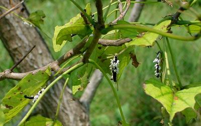
Poor little guys.
Almost every Catalpa worm (Ceratomia catalpae) on this tree had been parasitized by a Braconid wasp (Apanteles congregatus). The wasps lay eggs beneath the skin of the caterpillars, and the larvae feed on the them until they are ready to pupate. (The white cylinders are cocoons, not eggs.)
The wasps do the same thing to tomato and tobacco hornworms, amongst others, so are considered beneficial.
Poor little Catalpa worms, though.
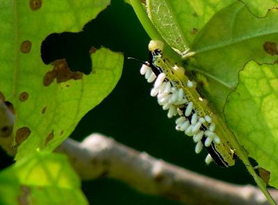
Mightily encumbered.
More than you ever wanted to know about Catalpa worm anatomy is here.
Monday, April 11, 2016
On the Road Again!
 We are taking a little vacation - wheeeeee! Hope you all had a Merry Christmas! We might get to an internets, but unsure at this point... And we'll definitely see you all in ! Happy New Year! xoxo
Sunday, April 10, 2016
Welton - Braunston - Ashby St Ledgers - Welton
Led by me, with Barry. Fine, sunny, warm to hot. Quite up and downy. Good views. 8.5 miles - the last two miles were in the car, when I'd forgotten to switch the machine off.
Welton is one of those villages set back from the main road - you need to be make a deliberate effort to go there. The main part of it is on the hill near St Martin's church and the White Horse pub.
 |
| St Martin's church from the rear |
 |
| Pub and church - above the pub door are the words "Abandon hope all ye who enter . . ." |

A short uphill stretch and we reach the canal, where we cross the bridge and turn right towards Braunston.
 |
| A narrowboat emerging from the Braunston Tunnel |

We have to leave the canal and walk over the hill. The tunnel's a good mile long.
 |
| Braunston lies ahead |
 |
| An air shaft for the tunnel |
 |
| Bicentenary plaque |


 We stop for an ice-cream at the canal shop before leaving the water and taking the Jurassic Way to Ashby St Ledgers.
We walk up to Braunston village, and take the road just by the Wheatsheaf - Ashby Road which goes to the right. We follow it until it bends to the right. At this point the old road is now a track leading straight ahead - towards Ashby St Ledgers.The track narrows to a path, and climbs up to a minor road, with great views behind. At the highest point, we turn right along the road, and very soon left, at a Jurassic way marker in the same direction as previously. The path goes downhill to the A361. We cross, pass the Old Coach Inn, and walk through the village, until a road junction just before the church.
 |
| the old stables |
 |
| Church and the gatehouse to the Manor. |
We take the road to the right, past a Co-op farm and a building labelled the Old Dairy. When we reach a junction our path goes slightly to the left, cutting off a long corner of the field. Then it's through a series of fields where rapeseed is just starting to show yellow.
 The path is clear and easy to follow up hill towards Welton. It comes out between houses on Ashby Road. All we have to do is work out where the church is and we can find our way back to the car.
There's some kind of treasure hunt going on - people with sheets of paper wandering around in groups - and cars driving slowly around.
 |
| Hunting for the answer - what happened to John? |
We're lucky enough to arrive at the church just as one of the churchwardens opens it - it's normally kept closed.
 The sad story of what happened to John is answered by this gravestone - poor little lad.
I wonder if this is "starved" as in "frozen" - a northern use of the word. My grandmother used to warn us we'd "be starved to death" if we didn't put our coats on in winter.
Whoever erected the stone seems to be making a big point about the neglectful parents . . .
Other walks touching this one:
Ashby SL, Braunston, Barby
Jurassic Way: Charwelton to Braunston
Jurassic Way: Braunston to Winwick
Thursday, April 7, 2016
Taking advantage of all the lake offers
This is the season of changeable weather. And Lake Michigan is highly responsive to those changes. One day it feels like fall, with strong winds out of the north, big waves, abandoned beaches and a chill in the air; the next it feels like summer, with warm breezes, gentle waves, motorboats zooming and the beaches full of bathers.
It would be easy to favor one type of day or the other, but we love both. On rough-water days, we can surf waves and play in clapotis. On calmer days, we can practice rescues and paddle some distance. Both prepare us for the real range of situations we encounter over time, and both are fun.
 |
| Yesterday we had the beach to ourselves. |
 |
| And the water, too. |
 |
| Today we worked on rescues with our friend Bonnie. |
 |
| And paddled past skyscrapers, sailors, motor boaters and beach volley ball players. |
It would be easy to favor one type of day or the other, but we love both. On rough-water days, we can surf waves and play in clapotis. On calmer days, we can practice rescues and paddle some distance. Both prepare us for the real range of situations we encounter over time, and both are fun.
Sunday, April 3, 2016
Doors Open Day

All across Scotland this weekend doors normally closed were open to the public. Lighthouses, former nuclear bunkers, castles that are private homes, masonic temples are just a few of the places that could be visited free of charge.
This is one normally closed door that I spotted as I passed the Sheriff Court - a Reliance prison van. It was full of eager public, with a British queue waiting outside, and unfortunately I didn't have time to wait.
Next year, we've decided, we must make some time for visiting the open doors. The city centre was thronged with people, Doors Open Day brochure in hand, happily intent in that special way that the Scots have when they're getting something for nothing.
Not Focused on Obedience... Preoccupied with this Picture...
 It's hard to concentrate on my broad jump when I'm thinking about Independence Lake (above). We're finally almost ready for our camping trip that will start next Tuesday and end on August 30.
  Barbara's started a new Broad Jump routine for me by adding a little jump after the B(ored) jump (heehee!). To encourage me to do more than plod over the thing and return to Ma after I jump it, Barbara put up a small jump to force a fast hop over the first part! It worked, darn it! I still have to go to obedience next Monday and then I'm off for two whole weeks woo hoo! Avalon also has started obedience and shows great promise - well... she high steps like an Arabian horse - it's unbelievable! But I'm the bigger sisfur and win all the important rounds heheheee! Care to spar with me to find out? Have a good week and weekend too! Loves you all!
Subscribe to:
Comments (Atom)