Tuesday, November 29, 2016

Adjusting to colder water and weather


Lake Michigan's surface water near Chicago dropped about 10 degrees over the past week. This morning's 19-knot winds beckoned, but the water temperatures whispered, "Bring your neoprene caps and poagies."

We suppose some people don't hear things like that.

After weeks of warm water, we were somewhat sad to find the lake back in the mid-50s. But hey, this is Chicago. And besides, our west coast friends consider temperatures like these normal.

We surfed and played a bit, then tried to convince one of the denizens of the doggie beach that we weren't deep sea aliens come to steal his tennis balls.

It's important, we figure, to get out on the water as the temperatures drop to soften the shock of winter's arrival. Poagies and all.


Going to hell


One of these days I promise to actually get a post uploaded right away. It won't be today however. In this case, I'm around nine days late in documenting what was one of the best rides of the year -- to a place called Hell's Hole, hidden in Mt Jerusalem National park. This day was made special because of what came before I got anywhere near the destination, and started with a climb over Tomewin right on sunrise. What followed was quite spectactular and totally unexpected.


I descended into the Tweed Valley, into almost freezing temperatures (4 degrees C on the valley floor), and into a thick mist and a southerly wind blast that came out of absolutely nowhere. This route passes the bottom of Mt Warning, but the mountain might as well have spent a morning at the beach for all I knew, as visibility was only around 200 metres or so. I was actually pondering whether or not the condensation in the air might clean some of the dirt off the bike, so thick was it. Yet by the time I started the next climb to the national park, it was all but gone.


There are some really stunning patches of rainforest in Mt Jerusalem National Park, but Spring is also the wildflower season. The flowers seen in this area don't seem to make it to the nearby Lamington or Nightcap national parks, but here they find a home. Today I was meeting some friends at the top of the final climb for the final walk to Hell's Hole itself, and the waterfalls that surround it. This is a truly beautiful area, and one that I only discovered, believe it or not, last year.


Today a few members of the group got even more ambitious, and tried to descend to the big rock pool at the bottom. Nobody made it of course, as I understand it has to be approached from a track on the other side, followed by a scramble along the creek. I've since looked at a topographic map of the area, which suggests that it may even be a different creek, but that's an adventure for another day. While this effort didn't make it to the rock pool, it did yield a slightly different view of the waterfall at the end that drops right into the Hole itself.


After all this it was time to retire to the cafe in Uki for (in my case) a double-serving of lunch before the ride home. If there was one sad thing to come from the day, it's looking at what the Tweed Shire Council have done to Urliup Road, as they appear to be preparing to seal what may be my favourite dirt road in the world at present. This would, of course, be a tragedy for all of mankind, but I guess it was inevitable sooner or later. Still, this would be an opportune time to remind the Tweed Shire Council of what happened last time they upset me. They have been warned!

Monday, November 28, 2016

Capture


I have a new computer that's taking a little getting used to. The pros are obvious: My m and n keys are no longer worn out, the case isn't cracked at the seams, and boy, is it zippy fast.
Really the only con is that many things work differently. As an official old person, I think I'm obliged to resist change. Or whine about it a little, at least.
Photoshop Elements will do so much more than my old mini-featured generic program. I couldn't resist the urge to make my bug photo look like a cartoon, as you see. But the features aren't intuitively obvious, and they're not much like the old Photoshop 3 I used to know.
You people with wide-screen computers were so sweet not to tell me how off-kilter I've been. I like my new screen, but some things (mainly my blog header) appear centered incorrectly. I haven't figured out how to fix that yet.
The screen is also very bright. So I may have trouble getting the photo levels right for a while.
I have a spiffy new Bluetooth mouse. No cords, it's great! But it has a bit of a tendency to drift to the left all on its own when I use my usual sofa-pillow-as-mousepad.
I will figure it all out eventually.

Saturday, November 26, 2016

Surprise Pressie

Mom tried to help me paw out our address, but it sure is messy! However, check out the cool address label! Wow!
Look who I got this neat package from! Huge woofs for this pawesome card!!! And look! I've already got my snooter deep into the box!
Oh sooo cool! I love this squeakie stuffie!!! I love it so much that...
... I immediately carry it two rooms away to my bed before I investigate the rest of the box! That's stuffie love!
Dad lures me back to this amazing-lookie box and you won't believe what's inside! Yumzers smell!
Ohhhhhhh! Cookies!!! Not only that! They are homemade by Sedona's Girl Twin! Givemeonegivemeonegivemeone Dad.... Please?????
Aren't these gorgeous? I don't know how she made them, but they are delicious as well as bootiful! She oughtta go into bizness hehee! And here's a movie of me sampling a couple of these exquisite petits-bones! Thank you so, so much Sedona and Girl Twin! xoxoxoxoxo
http://www.youtube.com/watch?v=qls3o7h2xjc

Sunday, November 20, 2016

Day 3 - BHFTF


And now for something completely different...
I took my time getting to the festival yesterday morning. The trail runners were just leaving - no time to get there to take photos. But, the group was organizing for freeriding.
We carpooled to Storm Mountain. The group started with hike-a-bike up the mountain. About a quarter up the trail (from one of the riders) I decided that was high enough, There was a good, rock decent there and 2 jumps.
Spent nearly 2 hours there shooting riders at this spot. The light played havoc with the camera light meter. Hope I can touch up a couple more of the photos.
Since I was in the area, and it was that time, lunch as the Gas Light.
Stopped HQ to checking my receipts and claim tickets for Beer-Muda. i was sure the Gas light was one of the sponsors, but they are not this year. So I only had the receipt for Friday lunch at the Firehouse.
Napped and did some stuff in the room. Then off the watch the Strider demo race. The Tri-athalon was just about to start at so stopped to take some photos of the start.

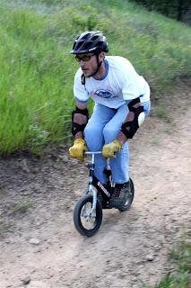
The Strider race was probably the highlight of the races at the festival. Big boys racing downhill on little bikes. The only way to describe the was by a photo.
The day ended with the BBQ. Grilled burgers of beef, venison, buffalo, veggy burgers, and chicken with all the fixin's. There was music and beer, sopped off by raffles.
A couple of glitches there. In interest of time, they started drawing winning tickets before everyone got their tickets. I was finishing in the food line when the raffle started. (I was fortunate to win cycling shorts - and they even fit me!)
Once I had some time to get over to get my beer (2 tickets came with your dinner), the keg was dry. Luckily, the Festival purchased a second keg. When I went for my beer, I took BOTH of my cups, lest they run out again. (They did but the party was almost done). When one of the workers of the festival said he was pretty sure the one group of raffle prizes were all there was, I was disappointed. There seemed to be more swag for the racers than raffle prizes. Alas, we were wrong there were another general raffle, Finally Beer-Muda Triangle raffle.
By the time everything ended, I was tired, cold, and my brain was fried from the noise. Took me some time to settle down to sleep.

Monday, November 14, 2016

Jurassic Way 1 - Banbury to Chipping Warden

Theoretically 11 miles, nearer 12.5 ( the garmin took a little while to pick up the satellites in this new area). We should have set off earlier in the day to give ourselves more time to explore Middleton Cheney and Wardington. Weather mostly fine, coolish, a couple of showers - the heaviest of them while we were having lunch. With Marta.


From the car park in Banbury, via the shopping centre for a quick coffee, and a visit to the Tourist Information Centre to pick up another map, we made our way south along the canal, from Banbury Lock, in the direction of the water's fall, past various narrowboats and a few sculptures.

the canal

Long John Silver or Captain Hook? I shoulda blurred out the background.


The start of a new adventure - with Banbury Lock in the background, the Jurassic Way starts - though we couldn't find a sign for it.


Someone's made a real effort with this waterside garden.

We're on the correct path. Just as well.


At this bridge the Jurassic Way leaves the canal and turns left, north-east heading towards the Cherwell, and the M40. The bridge crossing the Cherwell has a plaque.

Just after crossing the bridge the path goes alongside the river and under the motorway.

We could hear the noise clearly for quite some distance afterwards, as we walked across fields, over a railway bridge and past some agricultural buildings.


We're still on the right track
At a minor road we turned right, then left towards Warkworth. In Warkworth, we turned left to a footpath opposite Manor Farm. The path took us towards Overthorpe, passing a church at some distance on our right, then skirting Overthorpe along a tree lined path from which we could glimpse some splendid gardens. We then turned right towards Middleton Cheney across fields and past allotments, down to cross a stream and up into the large village.


We turned left and went across the by-pass ( A442) and into the High Street where we found the Take Thyme cafe and conveniently by-passed the worst shower of the day while we had our lunch. There is a heritage trail, but we had no time to follow it today.

I hadn't realised Middleton Cheney was big enough to have a secondary school, or so many small shops. According to the village website, there are plenty of ghosts in the village as well.


From the cafe we went along Church Lane, and found the footpath between houses. Soon after leaving the village, we crossed a field before walking alongside another one with llamas and sheep, and a tree surrounded by fallen apples which from a distance looked like unseasonal yellow flowers.

Onward and across the B4525, over more fields, where the way is pretty clearly marked, then through a wooded area. The map was useful to check where to cross a narrow section of wood before turning right along the edge and past Chacombe House before arriving at the village itself. The path climbs up into Chacombe through some woodland where signs are very clear. You leave the village from the junction of Silver Street with Silver Street North. You can see the church across the field, and there's a picnic area and a large stone.


From here the route as far as Wardington was straightforward, leading under the railway then uphill and across fields.

under the railway

some curious sheep


We had a small problem finding the way very close to Wardington, and came out about fifty yards too far along Thorpe Road, but it was plain from then on, as the path led us round the village, but at one point (in the Close) there was a sign simply saying footpath. We asked a local resident, who almost sent us back round the village, but finally showed us the nearest path, between some houses, and luckily the Jurassic Way was signposted at that point. Then there was one occasion when a sign was actually pointing ahead instead of left as it should have done. This made us walk all of an extra couple of hundred yards, but finally the route to Edgecote was clear. if we'd looked at the map instead of blithely following signs, we'd have been fine.

We met the road where there are a couple of cottages, then took the road to the right and followed it until it turned to the left into the village of Edgecote, just after the church.

From here we took a track, through a gate downhill to cross the Cherwell ( very small here), then up a gentle slope and into Chipping Warden.


Rain on lens again!


pdf fromNorthants C C - Banbury to Ashby St Ledgers

A video of this section - by voxley19 from August covering many of the same landmarks.

Sunday, November 13, 2016

Reptiles in the garden


Me: Look at this plant!
Friend on garden tour with me: Wow.
Me: The leaves look like they're made of scales. What do you want to bet that it's got snake in its name?
Friend: Or alligator!

We asked our hosts, and sure enough, it's Microsorium musifolium, Alligator Fern.*
Cool! I think I would have used snake, though.
Speaking of which, I spotted a big rat snake sneaking under the chicken coop yesterday. (Actually he was just sitting there, but he had a very sneaky air about him.) I ran for the camera, but he had slithered away by the time I got back.
We've been using golf balls as laying enticements. They say, "lay your egg here, this spot is great" in language that chickens almost can't help but agree with.
Lately though, the golf balls have disappeared. That snake had a suspiciously round lump near the end of its tail. And a stomach ache, I imagine.
-----
* Also known as Crocodile Fern. You will also see the botanical name as Microsorum musifolium (without the last "i" in the first word).